All Day Saturday & Sunday
SATURDAY NO. A1004-479 Nov. 27
Kagle Mtn. *8:30 AM
Hike 9, 1100 ft. ascent, Drive 80, Rated B-B
Charlie Ferguson, 828-625-2677 (cell: 828-778-2431), ccf108@gmail.com
P400 *Form carpools at Westgate, and meet leader at Pisgah Forest Bi-Lo at 9:05 AM. This loop hike will start from Cathey’s Creek Rd. and follow an overgrown forest road to the Art Loeb Trail, with lunch at the Butter Gap shelter. We’ll return via a no-name trail for variety. Nice views. Topos: Rosman, Shining Rock; also NatGeo map #780
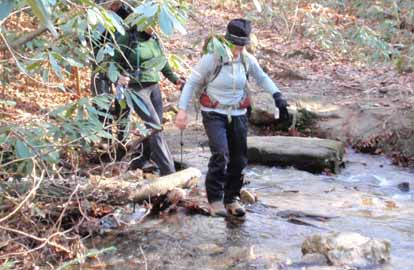
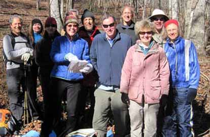
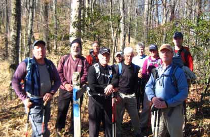
Photo by Carroll Koepplinger
Cool, sunny, no wind and clear air for nice views to the south and of Cedar Rock Mountain. Thirteen people went on this hike include two out of town visitors. Our gradual climb over 6 miles on FS road 5361 was a little more challenging due to heavy overgrowth and fallen tree tops. Only one place required a short bushwhack to get around a fallen tree. We had lunch at a campsite at the junction of the road and the Art Loeb trail, with views through the trees of the east face of Cedar Rock Mountain. A short walk on the Art Loeb to Butter Gap and then a two mile walk down another old un-maintained road/trail to our cars. Enough people walk on that trail to keep it open - a very nice place in the forest.--Charlie Ferguson
SUNDAY No. A1004-373 Nov. 28
Yellow Mountain *8:00 AM
Hike 10, 2900 ft. ascent, Drive 125, Rated A-AA
Brent Martin, 828-587-9453 (cell: 828-371-0347), brent_martin@tws.org
*Hikers must contact leader beforehand to register. Form carpools at Westgate, and meet leader at Franklin Bi-Lo at 9:30 AM. Get off US 441 bypass at US 64 Exit and go towards Franklin—Bi-Lo is on left side. We’ll hike in the Cowee Mtns on a heavily forested high altitude trail that ascends four peaks going in and three on the way back. Views from the Yellow Mtn. observation tower are great – a fine lunch spot. Strenuous but rewarding. A stop will be made at the rest area beyond Waynesville at 8:30 AM. Topos: Highlands, Glenville; also NatGeo map #785
SUNDAY NO. A1004-352 Dec. 5
Jones Gap Trail & Coldspring Loop 8:00 AM
(strenuous)
Hike 11, 1950 ft. ascent, Drive 80, Rated A-A
Carroll Koepplinger, 828-667-0723, carrollkoepp@bellsouth.net
We’ll hike up the Jones Gap and Tom Miller Trails past two waterfalls to US 276, then loop back via the Coldspring Trail. Several creek crossings which are usually dry unless there has been recent heavy rain. Second meeting place: Exit 53 of I 26, north end of Cracker Barrel parking lot, next to Upward Rd.) Topos: Standingstone Mtn., Cleveland, Table Rock; also Mountain Bridge Wilderness and Recreation Area Trail Map
Prior to leaving Westgate there were some pessimistic attitudes about the weather (lousy at Westgate). I assured them that we would have great weather conditions for the hike! Eleven CMC members left the trailhead at 9:15 am and returned 3:15 pm. We hiked 11.5 mi with an elevation climb of 1,958 ft. and took in the full flowing Jones Gap waterfall. There were several stream crossings which were flowing full and rapid. We were able to cross all of the streams with nary a wet boot (well, maybe just a little). Due to time & additional hiking of 3.2 mi. we wisely decided to skip viewing the Rainbow Falls. The weather? Sunny with few clouds & temps in the mid 30's with some occassional breezes, What could be greater?--Carroll Koepplinger
SUNDAY NO. A1004-545 Dec. 5
Bent Creek #11 – Boundary Trail *8:30 AM
(moderate)
Hike 8.3, 1100 ft. ascent, Drive 25, Rated B-B
Stuart English, 828-883-2447, stuengo@citcom.net
P400 *The only meeting place is Ingles parking lot across from Biltmore Sq. Mall. From Bent Creek Gap we will follow the MST to the Bent Creek Boundary Trail, on to Ingles Field Gap, to Ledford Branch Rd and down to Deer Lake Lodge Trail and the Rice Pinnacle parking lot. Great winter views. Car shuttle. Topos: Dunsmore Mt., Skyland; also NatGeo. map #780 and Bent Creek Trail map.
Having agreed to lead Stu English's hike along the Bent Creek Boundary on Dec. 5th I was disappointed to find that a 1.5 mile unmarked, unmaintained section of the trail was unpassable. So the three hikers who joined me on a cold (21 degree!), snowy Sunday morning took an alternate route up to the maintained portion of the Boundary Rd, beginning on FR479G and continuing up Greens Slick trail. After 3.2 miles of uphill we felt much warmer. We also cut the hike a little shorter at the end by taking an alternate route from Ledford Rd back to the Rice Pinnacle parking lot. We were back at our cars by 12:30 which allowed us to eat our lunches inside in the warmth rather than outside in the cold!--Marcia Bromberg
SATURDAY NO. A1004-679 Dec. 11
Elk Pasture Gap - Mt. Pisgah via MST 10:00 AM
Hike 7, 2200 ft. ascent, Drive 45, Rated B-AA
Paul Dickens, 828-476-0010, psdicken@charter.net
P400 We will hike the MST from the NC 151 / BRP junction to Buck Springs Gap, then up to the summit of Mt. Pisgah. Great views from Mt. Pisgah and from Little Pisgah Mountain if clear weather. Our return will be on the Blue Ridge Parkway if closed. Pack for wind and cold. Trip is dependent on weather and ability to reach the top of NC 151 by car. Topo: Dunsmore Mtn.; also NatGeo map #780
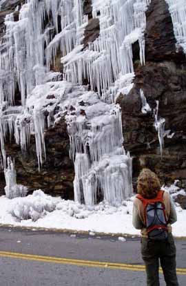 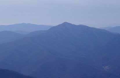
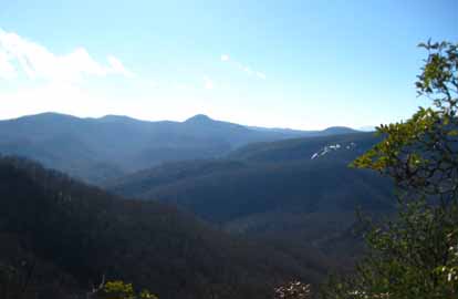
Photos by Paul Dickens
We had 11 hikers, including me. We went up the MST from Elk Pasture Gap and back down the closed BRP as planned, all in about 4.5 hours. We had fair weather, it started partly sunny and became overcast with temperatures in 30s to low 40s. It was hazy so views were muted. It was a good hike, and I enjoyed leading it. --Paul Dickens
(Editor's Note: Cold Mountain from Pisgah Summit.)
SUNDAY NO. A1004-418 Dec. 12
Newton Bald – Kanati Fork 8:00 AM
Hike 11.5, 3600 ft. ascent, Drive 120, Rated A-AA
Mike Knies, 828-628-6712, knies06@att.net
900M This great cold weather hike near Cherokee ascends Kanati Fork Trail, continues on Thomas Divide and then descends on the Newton Bald Trail. Nice scenery and a good workout. Car shuttle. Second meeting place: back of Post Office parking lot on US 276 in Maggie Valley at 8:30 AM, but call leader first. Topo: Clingman’s Dome; also NatGeo. map #317
Hike cancelled due to weather--Mike Knies
SUNDAY No. A1004-444 Dec. 19
Avery Creek Loop *8:00 AM
Hike 10, 1700 ft. ascent, Drive 80, Rated A-A
Michael and Kathy Cornn, cell: 828-458-1281 or 828-458-1282, mcornn@aol.com
P400 *Form carpools at Westgate, and meet leader at Pisgah Forest Bi-Lo at 8:35 AM. A nice hike featuring waterfalls, beaver dams, and winter scenery. We’ll first climb to Buckhorn Gap via Twin Falls, then follow the Black Mtn. Trail to Club Gap, with our return downhill on the Avery Creek Trail.. Topos: Pisgah Forest, Shining Rock; also NatGeo. map #780
Photos by Kathy Cornn and Danny Bernstein
A lucky group of 13 enjoyed an abbreviated hike of Avery loop. We had a slightly later start because one car took a scenic route through Hendersonville. Snow covered the access road, and part of the road was closed because of a dramatic landslide. We had a snack break at Twin Falls and hiked up to the second falls in search of the trail, but only found a great view. Later instead of turning left to the Buckhorn Gap shelter leaders turned right because of incomplete scouting. We had lunch to regroup and decided to take Clawhammer trail to Avery Creek trail back to the car. This meant the hike was 6 plus miles instead of 11 plus miles. Delicious apple bars made by Kathleen Hannigan, waterfalls and stream winter views kept the crowd from becoming a mutinous mob. Afterward some ate gelato in Brevard, Others ate at Dugan's, and some returned to Westgate. We hope to do the correct hike in the spring or early summer.--Kathy Cornn
SUNDAY No. A1004-589 Dec. 26
Shut-in Trail & Lake Powhatan loop 8:30 AM
Hike 9.6, 1600 ft. ascent, Drive 15, Rated A-A
Bob Hysko, cell: 828-243-3630, rhysko@yahoo.com
P400 This loop follows the MST west, then descends Sleepy Gap Trail, skirts Lake Powhatan and finishes with three miles on the Bent Creek Trail with a dirt road connecting parts of the trail. Second meeting place: BRP French Broad Overlook at 8:45 AM. Topos: Asheville, Dunsmore Mtn., also NatGeo. map #780 and Bent Creek Trail Map
--Back to Top
Half Day Sunday
HALF-DAY NO. H1004-707 Nov. 28
MST - Craven Gap to Haw Creek Overlook *12:30 PM
Hike 5.5, Drive 10, 700 ft. ascent, Rated C-C
Nonmembers, call leader, Jorge Munoz, 828-658-0606, jorgemunoz1927@hotmail.com
*Only meeting place: back parking lot of Folk Art Center. This is a delightful in-and-out hike along the MST from Craven Gap to Haw Creek Overlook where we shall enjoy beautiful views of the valley.
HALF-DAY NO. H1004-153 Dec. 5
Cove Creek/Caney Bottom Loop *11:00 AM
Hike 5, Drive 80, 1300 ft. ascent, Rated C-B
Nonmembers, call leader, Tom Joyce, 828-885-2152, tominbrevard@webtv.net
P400 *Meet at Westgate at 11:00 AM to form carpools, and meet hike leader at the Fish Hatchery off US 276 at 12:00 PM. This is a pleasant walk on a moderate grade through the woods, with streams, waterfalls, and a few large wildlife fields and a nice view of Looking Glass Rock.
HALF-DAY NO. H1004-638 Dec. 12
DuPont Forest Hooker Falls P.L. #4 - Cannon Creek to Rock Quarry *12:00 PM
Hike 5, Drive 70, 500 ft. ascent, Rated C-C
Nonmembers, call leader, Becky Elston, 828-749-1886 (cell: 828-702-9508), belston@tds.net
*Form carpools at Westgate, and meet hike leader at the Hooker Falls parking lot in DuPont at 12:45 PM. This in/out hike starts at Rich Mountain Road.
We have two inches of snow with ice underneath that. Can't even get out of my driveway. Mother Nature wins again.--Becky Elston
HALF-DAY No. H1004-429 Dec. 19
Hard Times Road to Rocky Cove Road to Bent Creek Road *1:00 PM
Hike 5, Drive 20, 500 ft. ascent, Rated C-C
Nonmembers, call leader, Thomas Crook, 828-545-8545, tmc3017@gmail.com
*Only Meeting Place: Ingles parking lot across from Biltmore Square Mall on NC 191. From there we will carpool with drivers who have Arboretum member parking privileges. We will hike in the Bent Creek area from the Arboretum recreation parking lot in an easy loop including the Hard Times Road to Rocky Cove Rd to Bent Creek Road.
HALF-DAY No. H1004-499 Dec. 26
French Broad River Greenway 1:00 PM
Hike 3.5, Drive 10, 200 ft. ascent, Rated C-C
Nonmembers call Paula Robbins, 828-281-3253, paularww@bellsouth.net
Get a little exercise and work off those holiday treats while viewing Asheville’s newest greenway. We will walk 3.5 miles from the Hominy Creek Park to the old French Broad River Park. Car shuttle.
--Back to Top
All Day Wednesday
WEDNESDAY NO. W1004-295 Nov 24
Pump Gap Loop 9:00AM
Hike 7, 1500 ft ascent, Drive 80, Rated B-B
Stuart English, 828-883-2447, stuengo@comporium.net
From Silvermine parking area, we will ascend to the AT, go to Lover’s Leap and return down to French Broad River, Hot Springs and our cars. Topo: Hot Springs, also NatGeo map #782
Nine of us hiked seven miles along the Pump Gap Trail, south on the Appalachian Trail, visited the top of Lover's Leap, and returned along the French Broad River back to the cars. It was a beautiful, sunny, mild day and perfect for hiking. The lovely woods with rhododendrons abound and the mountain views with the rapids of the French Broad River rushing along below from our observation point on the high cliffs was peaceful.--Tish Desjardins (Stuart was unable to lead the hike. Editor)
WEDNESDAY NO. W1004-310 Dec. 1
Jones Gap Trail: Pinnacle- Rim of the Gap. *8:30 AM
Hike 8.5, Drive 95, 1800 ft. ascent, Rated B-A
Jeff McGurk, cell: 864-921-6469, jbsbestfan@hotmail.com
*Form carpools at Westgate, and meet leader at Jones Gap parking lot at 9:45 AM. .At Jones Gap State Park in SC, we will go up the Pinnacle Pass trail over Little Pinnacle Mountain and take in two of the best views in the Jones Gap/Caesars Head parks. The way up includes some scrambling over boulders. We will have lunch at the second overlook. Then after back-tracking about a mile we will take a connector trail and return via the Rim of the Gap Trail. NOTE: There is a $2 charge per person at the park. Topo: Standingstone Mtn; also Mountain Bridge Wilderness Area trail map
Four hikers braved sleet and snow to get from Asheville to Jones Gap, and they were rewarded with a sunny day that saw the temperature reach 50 by lunch time. One of them commented that this was a perfect hike because after the first 2+ miles it was almost all level or downhill with only a few very small upward tracts. We enjoyed the great views and some new waterfalls and creeks which I had never seen before in the 10 or so times I had done this hike. These new waterfalls and creeks were the product of a 3 inch deluge of rain that came through the previous night. It was really quite fascinating and I intend to do this hike the day after another big rainstorm comes through and remember the camera. The new water effects made a few places on the first 2+ miles a little dicier, but we had no accidents. Sorry we have no pictures because everyone else forgot their camera also.--Jeff McGurk
WEDNESDAY NO. W1004-492 Dec. 8
Cookie Hike, Bent Creek Ramble *8:30 AM
Hike 7, Drive 10, 1200 ft. ascent, Rated B-B
Ken and Carol Deal, 828-281-4530, cnkdeal@charter.net
P400 *Only meeting place: Ingles parking lot on NC 191 across from Biltmore Square Mall. Moderate loop hike in the Bent Creek area. We will start from the parking area for Cold Knob Road (479H off Bent Creek Road beyond Lake Powhatan). Using a variety of short sections of trails, we will hike up to the MST, follow it past Sleepy Gap, and descend by the Stambaugh Trail to the Lake Powhatan picnic area for lunch and a cookie feast. Bring cookies to share. The afternoon walk back to the cars is approximately 2 miles. Topo: Asheville; also NatGeo map #780 and Bent Creek Trail Map.
Eleven stalwart hikers joined us for the longer portion of the Cookie Hike. Because it was an extremely cold day, we altered the hike so we could eat lunch, and share cookies, inside an Arboretum building. We parked at the French Broad River Parking area, hiked the Shut-In Trail to Hard Times Road, circled around the Arboretum, taking Carolina Mountain Trail to the Administration Building.
Thanks to the gracious people at the Arboretum, we ate a leisurely and comfortable warm lunch. Sherman's hike joined us there with another 7 hikers, including two of Sherman's daughters.--Ken & Carol Deal
ALTERNATE HIKE
WEDNESDAY NO. W1004-i Dec. 8
Cookie Hike, shorter version *10:00 AM
Hike 4, Drive 10, Rated C-C
Sherman Stambaugh, 828-254-1736
*Only meeting place: Ingles parking lot on NC 191 across from Biltmore Square Mall. We will start on the Lake Powhatan Connector and hike to the picnic area to meet the other group for lunch and to share cookies. After lunch we will return to the cars.
WEDNESDAY No. A1004-422 Dec. 15
Big Laurel - Pump Gap 9:00 AM
Hike 7, Drive 70, 2400 ft. ascent, Rated B-AA
Charlie Ferguson, 828-625-2677, ccf108@gmail.com
Starting at Hurricane, we'll hike the Big Laurel Creek trail down to the French Broad River, then up Pump Branch to Pump Gap, and the AT past Lover’s Leap before ending in Hot Springs. Medium pace, not slow. Nice scenery along the creeks and river. Possible stop at the hot tubs & supper after. Reservation required for hot tubs - call leader and bring your swimsuit if interested. Second Meeting Place: Big Laurel trailhead at 9:45 AM. Car shuttle. Topo: Hot Springs; also NatGeo. map #782
Hike cancelled due to weather.
WEDNESDAY NO. A1004-209 Dec 22
Buckwheat Knob – Coontree Loop 9:00 AM
Hike 8, 1900 ft. ascent, Drive 70, Rated B-A
Barbara Morgan, 828-738-3395 (cell 828-460-7066), bcmorg@hughes.net
P400 From the trailhead at Coontree Picnic area, we’ll climb along beautiful Coontree Creek through open forest up to Bennett Gap and on to Buckwheat Knob for lunch, then return via the other segment of the Coontree loop. A moderate woodland hike with exceptional views from the ridgeline. Second meeting place: Coontree Picnic area at 9:40 AM. Topo: Shining Rock; also NatGeo. map #780
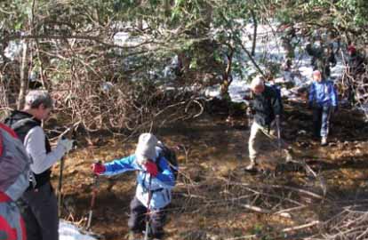
Photos by Barbara Morgan
Despite threats of a drizzly start, ten hikers joined me for this great winter hike. As the day progressed, the weather turned glorious - sunny, clear, and warm. Starting about 9:50, we ascended the left side of Coontree Loop and hiked out the ridge to Buckwheat Knob, then backtracked to descend by completing the loop and back to the cars at the Coontree Picnic Area about 2:40. The total hike was 8 miles, with 2200' gain/descent. There were excellent views of Looking Glass Rock and the several similar rock faces in that area off one side of the ridge and toward Mt. Pisgah and Turkeypen area on the other. All and all, a great day! I thank Debra Palmer for her help in scouting this hike.--Barbara Morgan
WEDNESDAY NO. W1004-268 Dec 29
Hospital Rock to Pretty Place and Rainbow Falls *8:30 AM
Hike 8, 2000 ft. ascent, Drive 95, Rated B-A
Ann Gleason , 828-859-9387 (cell: 252-412-8132), gleason.ann @gmail.com
*Form carpools at Westgate, and meet leader at Cracker Barrel parking lot (near road) at 9:00 AM. This strenuous loop hike in Jones Gap State Park takes us up to Hospital Rock and on up to the great view (and favorite wedding site) at Pretty Place for lunch. Then hike down rocky, steep trail to Rainbow Falls. Note: $2 charge per person in Jones Gap State Park. Topo: Standingstone Mtn.; also Mountain Bridge Wilderness Area trail map
Email your hike reports to Dave Wetmore. The deadline for reports is 9:00 p.m. on the Tuesdays before an eNews comes out. Reports for Wednesday hikes during the eNews publication week will appear in the following eNews--The Editor.
--Back to Top
All-day hikes submitted by Bruce Bente 692-0116, bbente@bellsouth.net . Driving distance is round-trip from Asheville. All Saturday and Sunday hikes assemble at Westgate Shopping Center near I-240 UNLESS OTHERWISE NOTED.
Half Day hikes submitted by Lucy Prim 828-693-6580 lucette32@mchsi.com.
Wednesday Hikes are submitted by Charlie Ferguson, 828-398-0213 ccf108@gmail.com and Ann Gleason, 828-859-9387,
gleason.ann@gmail.com .
The meeting place for each hike will be designated by the hike leader and appears in the hike description.
Driving mileage is round trip, based on the first designated meeting place. Meet at Westgate unless otherwise noted. |
