CMC Monthly Hike Reports
March 18th, 2011 -- Looking Back
All Day Saturday & Sunday SATURDAY NO. A1101-493 Feb. 26 SUNDAY NO. A1101-056 Feb. 27
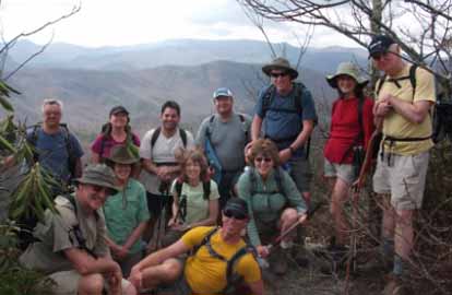
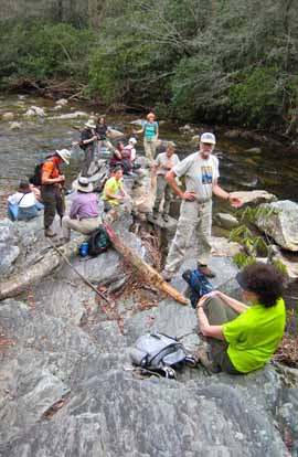
Photo by Kathy Cornn Thirteen hikers walked the ups and downs of the Turkey Pen roller coaster hike in 73 degree weather. We enjoyed a side hike to an overview on the Black Mountain Trail for lunch on a rock outcropping overlooking Looking Glass Rock. The leaders provided brownies. A few drops of rain fell when we were nearly to the cars, but stopped soon after. Kathy provided post hike treats. A normally complicated car shuttle was solved by Kathy and Michael who brought an extra car to the ending spot before the hike. Following the hike and a bird show at the parking lot, six hikers ate at Dugan's Pub where Paul attempted to earn a place on the Dougan's Burger Wall of Fame by eating two 8 ounce-burgers smothered in jalapenos and french fries. He didn't quite finish in 15 minutes so the wall of fame has yet to have a CMC member.--Michael & Kathy Cornn SUNDAY NO. A1101-235 March 6 Cancelled due to weather SUNDAY NO. A1101-716 March 6 Cancelled due to weather SATURDAY NO. A1102-691 March 12 SUNDAY NO. A1101-283 March 13
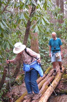
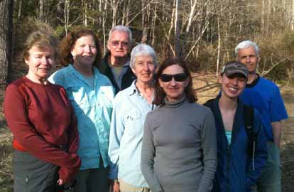
Photos by Danny Bernstein A switch to Daylight savings time didn't deter ten hikers from doing a beautiful Montreat ramble on a sunny Sunday. Several hikers came from Greenville, SC. Many of us were in shorts as we climbed to Lookout Rock from the Lake Susan parking lot, a steep climb. We took a variety of trails to Pot Cove Gap. Then we explored the new switchbacked Graybeard Trail which makes the trip to Graybeard longer but gentler. We found the turn to the waterfall but not Walker Knob shelter - we probably didn't go far enough. We returned on Graybeard Trail and went down the steep incline to the Graybeard parking area. By then, the tourists and their dogs, many not on leashes, were on the lower end of the trail. On the Mt. Mitchell road, we saw three men on dirt bikes - a first for me at Montreat. You can be sure that they were riding illegally. If you go into Montreat, you should get yourself a new 2010 map, which shows the new switchbacks. The free map is available at the General Store, opposite Lake Susan parking lot.--Danny Bernstein HALF-DAY NO. H1101-534 Feb. 27
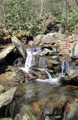
Photos by Charlie Ferguson There were 19 hikers on this wonderful hike on a beautiful day. We took our time. After about 45 minutes of hiking we ate lunch on a big rock jutting into the South Mills River. There were about 15 short rock hop stream crossings along the Pounding Mill trail. It was quite steep on the last 100 feet of climbing up to Poundingstone Mountain. On the way down the Mullinax trail we stopped at the old hunting lodge which is now a pile of rocks where the chimney used to be. The hike was a mile longer and 300 feet more of climbing than originally advertised, a bit more than a typical Half-Day hike but everyone did fine on it. Turkey Pen Road is still a bit rough in places but much better that it was a few months ago. Low clearance vehicle will still have to be very careful.--Charlie Ferguson HALF-DAY NO. H1101-171 March 6 Cancelled due to weather. HALF-DAY NO. H1101-639 March 13
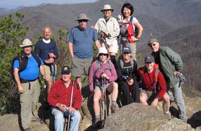
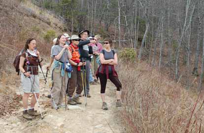
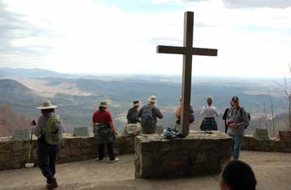
Photos by Ted Connors Nineteen hikers took advantage of the nice weather to hike old forest and CCC roads to Pretty Place from the NC side. We obtained permission to hike on property of Green River Preserve, starting with a one-mile drive up a rough and drive up an eroded old "road" and parking where the road forded a stream. From there we hiked up the road to the NC/SC border and then followed an old CCC road to Pretty Place. The road along the NC/SC ridgeline is part of the route of our hike that ascends Hospital Rock Trail and hikes to Pretty Place from the SC side. When we hiked under the Duke Energy Co. powerlines, there was evidence of new roads built by Duke all along the powerline, probably for a future construction project on the powerlines. The views from Pretty Place were as spectacular as usual and we had a lot of company from other visitors who were also out to enjoy the warm weather.--Bruce Bente New Wednesday Hikes--The MST Series Barth Brooker, the president of the CMC, will be leading a series of relaxed pace, medium length hikes of the MST on Wednesdays. The series will cover most of the MST which the CMC is responsible for maintaining - from Mount Mitchell to Balsam Gap near Waynesville. It is expected that it will take a number of months to complete the series. There will be a pause in the winter while the Blue Ridge Parkway is closed. The meeting place for each hike will be at the Folk Art Center - milepost 382 on the Parkway at 10:00 AM. Meeting at the trailhead for each hike may be possible. The distance covered will be of easy to medium difficulty. The pace will be relaxed so the hikes will end anywhere from 2:00 - 3:30. Most hikes will involve a short car shuttle. These hikes will not be announced in the Let's Go newsletter so check the Wednesday hike schedule on the Web site for updates. Great for those who want a short relaxed hike or would like to see what hiking is like. Hikes will be added on each Wednesday as they are developed and experience with the first ones are evaluated. WEDNESDAY NO. W1101-271 Feb. 23
Photo by Rich Sampson On an earlier scout we discovered that the first half mile of the logging road was badly overgrown and almost completely blocked by fallen trees. Instead of bushwhacking down to the old logging road as described in the database, we continued along the ridge following an old trail that required a great deal of climbing over and around blow downs and overgrowth. We completed the hike along Paddy’s Branch and came out on Curtis Creek Road with a 3 mile shuttle back to the cars at the campground. The weather was perfect – clear and cool with a warm sun, and a cool breeze coming up the east side of the ridge.--Rich Sampson WEDNESDAY NO. W1101-278 March 2 WEDNESDAY NO. W1101-471 March 9 WEDNESDAY NO. W1101-515 March 16
Email your hike reports to Dave Wetmore. The deadline for reports is 9:00 p.m. on the Tuesdays before an eNews comes out. Reports for Wednesday hikes during the eNews publication week will appear in the following eNews--The Editor. All-day hikes submitted by Bruce Bente 692-0116, bbente@bellsouth.net . Driving distance is round-trip from Asheville. All Saturday and Sunday hikes assemble at Westgate Shopping Center near I-240 UNLESS OTHERWISE NOTED. Half Day hikes submitted by Bonnie Allen, 828-645-0357, bonnie@allencats.com Wednesday Hikes are submitted by Charlie Ferguson, 828-398-0213 ccf108@gmail.com and Ann Gleason, 828-859-9387, gleason.ann@gmail.com . The meeting place for each hike will be designated by the hike leader and appears in the hike description. Driving mileage is round trip, based on the first designated meeting place. Meet at Westgate unless otherwise noted. |